
| wiki | search |
Geocoding transfers location data, e.g. country and city names or Postal codes into geographic coordinates (Latitude and longitude).
Several types of location data are supported:
- country names
Country names may be specified in various languages or by ISO 3166 two- or three-letter codes.
Example: "DE", "Deutschland", "Germany", "Tyskland". - country name and city name
The free service from GeoNames (GeoNames) is used for geocoding of country name and city name. The data is queried via a webservice, which requires internet access and takes some time. Note that there is a maximum of geocoding requests per hour and per day, so this geocoder might be temporary unavailable.
Example: Münster, Germany - country 2 letter ISO + Postal codes
ISO 3166 two-letter code in combination with Postal codes. Data must be in form "DE, 48161", i.e. country code followed by comma and then the Postal code.
Example: "DE, 48161". - Postal codes for specific countries
Only the Postal code for the selected country must be supplied.
Example: Postal codes for DE: "48161", "97074". - Google Maps location
The Google Geocoding API for geocoding is used to translate any address that Google Maps can resolve.
Note: the Google Geocoding API may only be used in conjunction with a Google map; geocoding results without displaying them on a Google map is prohibited. Furthermore, it is not allowed to use locations obtained through this Geocoder in conjunction with a non-Google map!
For complete details on allowed usage, see Maps API Terms of Service License Restrictions.
Note on the Postal codes:
To protect privacy, only a prefix of Postal codes can be given in the data. The software then calculates the center points of all known Postal codes that starts with the given prefix. Example: "DE, 481". For some countries (e.g. Great Britain), Postal codes are only available to a certain depth, which will result in imprecise results for longer Postal codes
Additional information must be supplied:
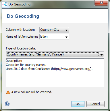
- Column with location: Choose which column contains the country/city name or the Postal codes.
- Name of lat/lon column: Enter a name for the column where the resulting latitude/longitude should be stored. This column may already exist. Existing values are not overwritten. If the column does not exist, a new column is created.
Note: Some of the geocoding data is provided by Geonames.org and other providers. Ridom does not guarantee that the geocoding results are complete and/or correct.